Sandy Cay and the South China Sea Dispute: A Comprehensive Overview
1. Introduction
The South China Sea is one of the world’s most contested maritime areas, rich in natural resources and vital to international shipping. It is also a flashpoint of intense geopolitical rivalry, particularly involving China and several Southeast Asian nations, notably the Philippines. Among the many contested features in this region is Sandy Cay — a small cluster of sandbars near Thitu Island. Despite its tiny size, Sandy Cay has recently become the center of escalating tensions between China and the Philippines. Understanding Sandy Cay’s importance requires a detailed look at its geography, the recent events surrounding it, and its significance in the broader struggle for control over the South China Sea.
2. The Geographic Setting of Sandy Cay
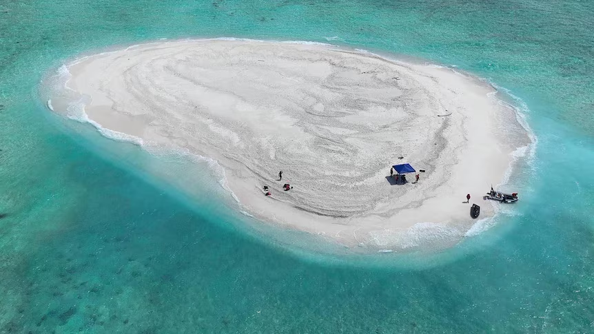
Sandy Cay is not a single island but a series of sandbars located just northwest of Thitu Island, one of the major Philippine-held features in the Spratly Islands. Specifically, Sandy Cay lies about 1.5 nautical miles northwest of Thitu Island and approximately 9 nautical miles northeast of Subi Reef, which is occupied and heavily fortified by China.
Unlike larger islands that can sustain life or human habitation, Sandy Cay consists of shifting sandbars — tiny, low-lying landforms exposed only at low tide or during calm conditions. Yet under international maritime law, particularly the United Nations Convention on the Law of the Sea (UNCLOS), even a small rock or sandbank can have important legal implications if it remains above water at high tide. If classified as a “rock” that is above water permanently, Sandy Cay could potentially generate a 12-nautical-mile territorial sea.
Thus, despite its diminutive physical size, Sandy Cay’s legal and strategic implications are outsized. Its proximity to Thitu Island, which hosts a small civilian population and a military presence, further intensifies its importance for the Philippines.
3. Meaning of “Sandy Cay” and Cultural Perspectives
The name “Sandy Cay” simply refers to a sandy island or sandbank — “cay” being a term derived from the Spanish “cayo,” meaning a small, low island. Cays are formed over coral reefs and are typically composed of sand or sediment. They are fragile and can shift over time with currents and storms.
For the Chinese, Sandy Cay is part of what they call the “Nansha Islands” (their name for the Spratlys) and is integrated into their broader territorial claims based on the controversial “nine-dash line.” The Chinese government refers to Sandy Cay and surrounding features using Mandarin names like “Tiexian Tan,” emphasizing historical rights and maps dating back centuries.
For Filipinos, Sandy Cay represents sovereign national territory and the country’s rights under international law, particularly following the 2016 Permanent Court of Arbitration ruling, which favored the Philippines and invalidated much of China’s expansive claims.
Thus, Sandy Cay symbolizes more than just a sandbar; it embodies questions of national identity, historical narrative, and legal sovereignty.
4. The Recent Display of Flags: A Tense Confrontation
In April 2025, Sandy Cay became the site of a highly symbolic and provocative confrontation. Chinese coast guard personnel landed on the sandbars and planted the Chinese flag, asserting what they called “maritime control operations.” These actions coincided with growing assertiveness by China in the South China Sea, particularly around Philippine-held territories.
In response, Philippine authorities undertook a bold maneuver. Personnel from the Philippine Coast Guard, Navy, and Maritime Police conducted a coordinated operation, landing on Sandy Cay to raise the Philippine flag. This move was widely publicized within the Philippines as an act of defending national sovereignty against foreign encroachment.
These actions are not merely symbolic. By physically occupying and flagging Sandy Cay, each country is attempting to demonstrate “effective occupation,” a principle in international law that can strengthen claims to disputed territory. In contested maritime zones, “possession” can have powerful legal and diplomatic implications.
The raising of flags thus marked a dangerous escalation. The fact that both sides undertook physical activities on Sandy Cay without resorting to immediate armed conflict shows both the intensity of their claims and the caution each side exercises to avoid open war — for now.
5. Why Sandy Cay Matters Strategically
Despite being nothing more than a collection of sandbanks, Sandy Cay has significant strategic importance.
First, it sits within the territorial waters that could be generated by Thitu Island, a major Philippine outpost with both military and civilian populations. Thitu Island is critical for the Philippines’ ability to project power and maintain a presence in the Spratlys.
Second, the legal status of Sandy Cay could impact broader maritime entitlements. If Sandy Cay is treated as a permanent feature above water at high tide, it could generate its own territorial sea, influencing fishing rights, access to undersea resources, and control over key maritime routes.
Third, Sandy Cay’s proximity to Subi Reef — a massive Chinese military installation — makes it a frontline position in the geopolitical struggle. Subi Reef has been transformed by China into a major artificial island with an airstrip, radar systems, and defensive weaponry. Maintaining a Philippine presence at Sandy Cay, therefore, serves as a counterweight against China’s military encirclement of Thitu Island.
Finally, Sandy Cay is a symbol. In the eyes of both Beijing and Manila, control over even the smallest piece of territory in the South China Sea serves as a test of political will, national pride, and international standing.
6. The Broader Geopolitical Context
The Sandy Cay confrontation is not happening in isolation. It occurs against the backdrop of intensifying U.S.-Philippines security cooperation, highlighted by large-scale joint military exercises known as “Balikatan.” In 2025, more than 14,000 troops participated in Balikatan exercises, focusing on joint defense, cyber warfare, and countering amphibious threats.
These exercises send a clear message: the Philippines is not alone. The United States, bound by a mutual defense treaty, is signaling its readiness to support Manila if Philippine forces come under armed attack in the South China Sea.
China, for its part, views these developments with suspicion and has ramped up its maritime activities, deploying coast guard and “maritime militia” vessels to contested areas, establishing administrative control where possible without triggering open military conflict.
Thus, the struggle over Sandy Cay mirrors the larger strategic competition between China and the U.S.-aligned powers for dominance over the South China Sea, an area through which trillions of dollars of global trade flows annually.
7. The Biggest Island in the South China Sea
While Sandy Cay is among the smallest features, the South China Sea is also home to Itu Aba Island (Taiping Island), the largest naturally occurring island in the Spratlys. Itu Aba is administered by Taiwan and spans roughly 46 hectares. It has a freshwater source and supports limited agriculture, features important for claims under UNCLOS.
In contrast, many other features — including Sandy Cay — are too small or too temporary to support permanent human habitation, which affects their legal status.
Itu Aba’s importance also highlights the fragmentation of claims: Taiwan, China, the Philippines, Vietnam, and Malaysia all hold positions on various features, resulting in a tangled web of disputes that no single diplomatic framework has fully resolved.
8. Challenges in Resolving the Sandy Cay Dispute
Resolving disputes over features like Sandy Cay is extraordinarily difficult for several reasons.
First, nationalism runs deep. Both Chinese and Filipino leaders face strong domestic pressure not to appear weak or concede territory.
Second, legal ambiguity exists. While international law provides some guidance, it often depends on facts on the ground — such as whether a feature is submerged at high tide — which are subject to environmental changes and political interpretation.
Third, there is the asymmetry of power. China possesses vastly superior military capabilities compared to the Philippines, and while Manila has allies like the United States, there is no guarantee of immediate intervention in lower-level confrontations.
Finally, the stakes are high. Beyond the immediate control of a few sandbars, what is at stake is access to fishing grounds, oil and gas reserves, and strategic control over one of the world’s busiest shipping lanes.
9. Conclusion
Sandy Cay’s sudden prominence in 2025 serves as a potent reminder that in geopolitics, even the smallest places can hold immense significance. A few sandbars in the middle of the South China Sea have now become emblematic of national sovereignty, regional stability, and global power rivalry.
For the Philippines, Sandy Cay represents the challenge of defending sovereign rights against a much more powerful neighbor. For China, it is another piece in its broader strategy to assert dominance over the South China Sea.
As flag-raisings give way to more regular confrontations, the future of Sandy Cay remains uncertain. What is certain, however, is that this tiny collection of sandbars will continue to play an outsized role in shaping the security architecture of Southeast Asia and beyond.